Holiday planning
Dachmarke Suedtirol
Holiday planning
telephone-white Call us email-white Write us whatsapp-white WhatsApp arrow-white 360° View

Chestnut Trail | Stage 2

From Feldthurns to Klausen

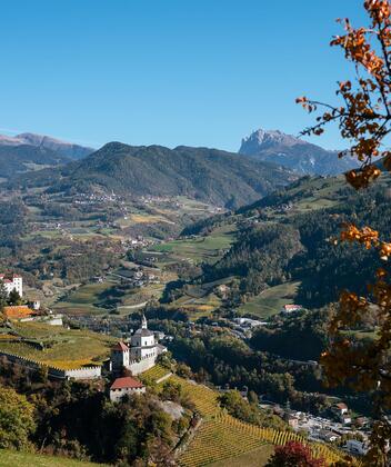
The second stage of the trail leads across the sun-drenched low mountain terrace of Feldthurns to Klausen. During your hike you can discover sights worth seeing, such as Velthurns Castle, the prince-bishop's summer residence from the late 16th century or the Säbener Berg with Säben Monastery and its Holy Cross Church. Along the way, you can always stop off at rustic wine taverns and on the descent to the artist town of Klausen, you will be rewarded continuously with magnificent views.

Route length: 5.8 km
Metres in height ascent: 95 m
Metres in height descent: 428 m
Average walking time: 1:55 h

Route:
After visiting Velthurns Castle in Feldthurns, walk through the village centre in a southerly direction. Cross the village passing Laurentius Church and walk straight
on until you reach the Antonius Chapel and the large chestnut tree (natural monument) on the left side street. Continue towards Pedratz. After about 200 m, cross a bridge and turn right up to the Radoar farm (refreshment stop)

. Here you follow the field path, overcome a shorter steep slope and reach the wide Höfeweg trail (carved sculpture on the left), which leads through a beautiful chestnut grove, here called "Keschtnloach", to the Weinbrenner farm. After walking through a shady part of the forest, you reach the farmstead of the "Moar zu Viersch" with its beautiful meadow chapel dedicated to St. Katharina (old estate, wine tavern). The view of the Dolomite peaks of the Geisler group, the Furchetta, the massive Sass Rigais and the Fermeda peaks is particularly beautiful from here.


You now hike over a hill covered with mixed forest and mighty chestnut trees and then through orchards to the hamlet of Pardell (775 m, Huber Inn, Obergostnerhof farm shop). Here you follow the asphalt road downhill in road bends to Säbener Hof and over the wide field paths down towards Säben. After a water reservoir, you reach the saddle, between the Säbener Berg and the slopes of Pardell. Now begins a short but very steep stage of trail that leads directly into the courtyard of the Säben Monastery.
You can visit the Chapel of Grace, the Church of the Holy Cross and the Monastery Church. Since 2024 Father Kosmas Thielmann OCist, a Cistercian monk from Heiligenkreuz Abbey in Austria, has been living in Sabiona Monastery.

Now the path leads slightly downhill to the right through a rock tunnel (710 m). Shortly afterwards you reach the Liebfrauenkirche (Church of Our Lady), which can be visited on guided tours or during certain opening hours in summer. The descent to Klausen is on the paved station path to Branzoll Castle and via the stairway directly down to Klausen (523 m).


Further information
How to arrive & parking | Tappa 2
Directions:
Take the A 22 motorway – Exit: Klausen/Gröden.
Continue to Feldthurns.

Parking:
In Feldthurns

Public transport:
By train to Klausen and by bus to Feldthurns.
Bus 342 from Brixen to Feldthurns
Bus 343 from Klausen to Feldthurns
Accommodations & stops | Stage 2
FELDTHURNS
Wöhrmannhof
Wehr 5 Via Wehr
Tel. +39 0472 855 250
info@woehrmannhof.com
www.woehrmannhof.com

bett 

Landgasthof Wöhrmaurer
Wehr 3 Via Wehr
Tel. +39 329 417 57 89
info@woehrmaurer.com
www.woehrmaurer.com

bett icon-essen

Brunnerhof

Brixnerstraße 1 Via Bressanone
Tel. +39 0472 855 121
info@brunnerhof.bz.it
www.brunnerhof.bz.it

bett 

Hotel Oberwirt
Dorfstraße 6 Via Paese
Tel. +39 0472 855 212
info@hotel-oberwirt.it
www.hotel-oberwirt.it

bett icon-essen

Aktiv-Vital Hotel Taubers Unterwirt
Josef-Telser-Straße 2 Via Josef-Telser
Tel. +39 0472 855 225
info@unterwirt.com
www.unterwirt.com

bett icon-essen

Teutenhofer Hof

Josef-Telser-Str. 1 Via Josef-Telser
Tel. +39 349 449 7013
info@teutenhofer.com
www.teutenhofer.com

bett 

Vinum Feldthurnerhof Panorama-Wellness
Guln 1 Via Gola
Tel. +39 0472 855 333
hotel@feldthurnerhof.com
www.feldthurnerhof.com

bett icon-essen

Schnellehof
Guln 8 Via Gola
Tel. +39 0472 855 499
margitschnellehof@yahoo.com
www.schnellehof.com
bett 

Haus - Casa Wiesenrain

Guln 5 Via Gola
Tel. +39 0472 855 306
info@wiesenrain.eu
www.wiesenrain.eu

bett 

Ferienhaus Tauber
Säbenerweg 5 Via Sabiona
Tel. +39 0472 855 206
haus_tauber@hotmail.com
bett 

Haus - Casa Moosanger

Säbenerweg 3 Via Sabiona
Tel. +39 0472 855 417
haus.moosanger@rolmail.net
bett 

Pension Huberhof
Pedratz 12
Tel. +39 0472 855 235 // +39 328 138 60 50
info@pension-huberhof.com
www.pension-huberhof.com

bett 

Oberweinbrenner
Guln 27 Via Gola
Tel. +39 348 698 3094
hubert.oberhofer@cmail.it
www.oberweinbrenner.eu

bett 


KLAUSEN
Haus - Casa Sonnegg
Verdings 29 Verdignes
Tel. +39 0472 855 476
margit@haussonnegg.it
www.haussonnegg.it
bett

Gnolhof
Verdings 3B Verdignes
Tel. +39 0472 855 412 // +39 340 346 06 89
info@gnolhof.com
www.gnolhof.com
bett 

Gasthaus - Albergo St. Valentin
Verdings 27 Verdignes
Tel. +39 0472 857 099
info@stvalentin.net
www.stvalentin.net
bett icon-essen

Moar zu Viersch
Verdings 22 Verdignes
Tel. +39 0472 855 489
martin.torggler@outlook.com

bett icon-essen

Gasser-Obergostnerhof
Pardell 51 Pradello
Tel. +39 0472 855 548 // +39 347 895 5405 // +39 340 493 5749
nadja@gasser.bz.it
www.gasser.bz.it
bett 

Gasthof - Albergo Huberhof

Pardell 50 Pradello
Tel. +39 0472 855 479
info@gasthaus-huber.it
bett icon-essen

Residence Laitacherhof

St. Josef 6 San Giuseppe
Tel. +39 347 0600846
info@laitacherhof.it
www.laitacherhof.it
bett

Hotel Sylvanerhof
Laitach 34 Coste
Tel. +39 0472 847 557
info@sylvanerhof.com
www.sylvanerhof.com
bett icon-essen 

Klostersepp
St. Josef 30 San Giuseppe
Tel. +39 0472 847 550
Info@klostersepp.com
www.klostersepp.com
bett icon-essen

Hotel Camping Ansitz Gamp
Griesbruck 10
Tel. +39 0472 847 425
info@camping-gamp.com
www.camping-gamp.com
bett 

Genusshotel Spitalerhof
Leitach 46 Coste
Tel. +39 0472 847 612
info@spitalerhof.it
www.spitalerhof.it
bett icon-essen

Hotel Brunnerhof
Griesbruck 19
Tel. +39 0472 847 622
info@brunnerhof.it
www.brunnerhof.it
bett icon-essen

Hotel Bischofhof
Griesbruck 4
Tel. +39 0472 847 448
info@bischofhof.it
www.bischofhof.it
bett 

Gasthof Walther von der Vogelweide
Oberstadt 66 Cittá Alta
Tel. +39 0472 847 369
info@vogelweide.it
www.vogelweide.it
bett icon-essen

Hotel Schmuckhof/Torgglkeller
Gerbergasse 24 Via Conciatori
Tel. +39 0472 847 026
info@schmuckhof.it
www.schmuckhof.it
bett icon-essen

Cityhotel B&B Goldener Adler
Auf der Frag 14 Piazza Fraghes
Tel. +39 0472 846 111
info@goldeneradler.it
www.goldeneradler.it
bett 

Hotel Der Rierhof
Fragburg 7 Via Fragburg
Tel. +39 0472 847 454
info@rierhof.com
www.rierhof.it
bett icon-essen

Hiking trail Hiking trail  · South Tyrol Open

Chestnut Trail from Feldthurns to Klausen

Responsible for this content
Klausen, Barbian, Villanders, Feldthurns
  • Keschtnweg
    Keschtnweg
    Photo: Klausen, Barbian, Villanders, Feldthurns
Map / Chestnut Trail from Feldthurns to Klausen

Selected alternatives for you
    The Chestnut Trail delights with chestnut groves, forests and meadows – a unique nature and cultural experience through South Tyrol’s landscapes.
    Open
    Easy
    Distance 6 km
    1:40 h
    95 m
    423 m
    893 m
    522 m
    The Chestnut Trail leads through South Tyrol’s stunning landscapes, passing colourful mixed forests, lush meadows and charming chestnut groves. From Varna near Brixen, the trail stretches along the slopes of the Isarco Valley to the Renon plateau and towards Bolzano.

    A unique experience in every season, the trail combines beautiful nature with local specialities, cultural landmarks and fascinating legends along the way.
    Responsible for this content
    Klausen, Barbian, Villanders, Feldthurns 
    Difficulty
    Easy
    Overall difficulty
    Easy

    Derived from the technical difficulty and the stamina requirements.

    Experience
    Landscape
    Highest point
    893 m
    Lowest point
    522 m
    Best time of year
    Jan
    Feb
    Mar
    Apr
    May
    Jun
    Jul
    Aug
    Sep
    Oct
    Nov
    Dec

    Track types

    Show elevation profile

    Roadbook

    The starting point is the Church of St. Anthony in Feldthurns. Following the signs for the “Chestnut Trail”, the route leads via Pardell to Säben Abbey. From there, the trail descends to Klausen with beautiful views along the way.
    Rest stop
    Tip
    Nearby
    Top Partner
    Waypoint
    Start point
    End point
    Low point
    High point
    Forecast
    Today {low} to {high} and {precipitation} of {precipitation_type}
    show {x} more
    Photo
    Video
    Parking place at fire brigade Velturno
    Klausen: Associazione Turistica
    Isarco - Eisack
    Dürerstein
    Sabiona
    Wunderful view to the Dolomites
    Pedraz
    Sattel nördlich Kloster Säben

    Public transport

    The hike is easily accessible by public transport: bus no. 343 connects Klausen with Feldthurns, while bus no. 342 runs from Brixen to Feldthurns.

    Directions

    Leave the motorway at the Klausen/Chiusa exit. At the first roundabout, take the first exit, and at the next roundabout, take the second exit. Continue along the road for a few metres, then turn right towards Feldthurns. Follow the road to Feldthurns.

    Parking

    At the entrance to the village, free parking is available on both the left-hand side (next to the fire station) and the right-hand side (next to the recycling centre). There is also a paid parking garage located right next to them.

    Coordinates

    DD
    46.668408, 11.597762
    DMS
    46°40'06.3"N 11°35'51.9"E
    UTM
    32T 698711 5171594
    w3w 
    ///agrees.regatta.ripen
    Get there by train, car, bike, or on foot!

    Similar routes nearby

    • Feldthurns - Säben - Hieng - Feldthurns
    • From Feldthurns to to the waterfalls of Schrambach
    • Feldthurns/Velturno - Garn/Caerna - Klausner Hütte/Rifugio Chiusa
    • From Feldthurns to Verdings
    • Panoramic way in Velturno/Feldthurns
    • Tour of the villages Feldthurns-Schnauders-Garn-Verdings
    • Garn - Königanger peak - Radlsee lake
     These suggestions were generated by our system
    Status
    Open
    Difficulty
    Easy
    Overall difficulty
    Easy

    Derived from the technical difficulty and the stamina requirements.

    Distance
    6 km
    Duration
    1:40 h
    Ascent
    95 m
    Descent
    423 m
    Highest point
    893 m
    Lowest point
    522 m
    Family-friendly Linear route

    Weather at the starting point

    14-day forecast

    Statistics

    • Content
    • Show images Hide images
    Features
    Maps and trails
    Nothing selected - click and drag in the elevation profile to zoom
    Distance
    Duration
    Ascent
    Descent
    Elevation profile